
Application of aerial photography with visible atmospherically resistant index by using unmanned aerial vehicles for seagrass bed classification in Kung Krabaen Bay, Thailand
Article Sidebar
Main Article Content
Abstract
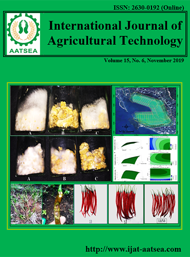
The classification based on VARI resulted in three classes, namely (i) long-leaved species (Enhalus acoroides), (ii) short-leaved species (Halodule pinifolia and Halodule uninervis), and (iii) other objects. The aerial photographs showed clearly differentiation in seagrass species which different digital number value ranges with the VARI approach. The overall accuracy of visual interpretation was higher than supervised classification of 88.88% and 61.11%, respectively. The technique confirmed to be useful for seagrass species mapping in other areas. The results concluded that H. pinifolia and H. uninervis that distributing on sandy clay and seashell substrates, while E. acoroides distributed only on sandy areas.
Article Details

This work is licensed under a Creative Commons Attribution-NonCommercial-NoDerivatives 4.0 International License.
References
Adi, N. S. (2015). Characterisation of the light environment and biophysical parameters of seagrass using remote sensing. (PhD. Thesis), University of Queensland, Australia.
Albertz, J. (2007). Einführung in die Fernerkundung Grundlagen der Interpretation von Luft-und Satellitenbildern. WBG Darmstadt, Germany.
Dekker, A. G., Brando, V. E. and Anstee, J. M. (2005). Retrospective seagrass change detection in a shallow coastal tidal Australian lake. Remote Sensing Environment, 97:415-433.
Dekker, A., Brando, V., Anstee, J., Fyfe, S., Malthus, T. and Karpouzli, E. (2007). Remote sensing of seagrass ecosystems: use of spaceborne and airborne sensors. Seagrasses: biology, ecology and conservation, pp. 347-359.
Department of marine and coastal resources (2016). Conservation and restoration of seagrass by transplanting. Department of marine and coastal resources, Thailand.
DroneDeploy (2018). How to select the right DroneDeploy Plan for your drone program. Retrieved from https://prismic-io.s3.amazonaws.com/dronedeploy-www%2F0fac4d0d-769c-4faa-8e45-7a3c96b50f78_dronedeploy_pricing-11_2018. pdf.
Duffy, J. (2006). Biodiversity and functioning of seagrass ecosystems. Marine ecology-progress series, 311:233-250.
Gitelson, A. A., Stark, R., Grits, U., Rundquist, D., Kaufman, Y. and Derry, D. (2002a). Vegetation and Soil Lines in Visible Spectral Space: A Concept and Technique for Remote Estimation of Vegetation Fraction. International Journal of Remote Sensing, 23:2537-2562.
Gitelson, A. A., Kaufman, Y. J., Stark, R. and Rundquist, D. (2002b). Novel algorithms for remote estimation of vegetation fraction. Remote sensing of environment, 80:76-87.
Kushwaha, S. (2008). Geoinformatics-technology and applications. ENVIS newsletter, 14:2-13.
Lebourgeois, V., Begue, A., Labbe, S., Mallavan, B., Prevot, L. and Roux, B. (2008). Can commercial digital cameras be used as multispectral sensors? A crop monitoring test. Sensors, 8:7300-7322.
Marine and coastal resources research and development center the eastern gulf of Thailand. (2006). Seagrasses in Thai waters. Department of marine and coastal resources, Thailand.
Mumby, P. J., Green, E. P., Edwards, A. J. and Clark, C. D. (1997). Measurement of seagrass standing crop using satellite and digital airborne remote sensing. Marine ecology progress series, 159:51-60.
Paibulkichakul, B., Jansang, P. and Paibulkichakul, C. (2016). Distribution of seagrass (Enhalus acoroides) and relationship with environmental factors at Kung Krabaen Bay, Chanthaburi province. KKU science journal, 44:201-211.
Perez, M., Aguera, F. and Carvajal, F. (2013). Low cost surveying using an unmanned aerial vehicle. International archives of the photogrammetry, remote sensing and spatial information sciences, XL-1/W, 2:311-315.
Sagawa, T., Boisnier, E., Komatsu, T., Mustapha, K. B., Hattour, A., Kosaka, N. and Miyazaki, S. (2010). Using bottom surface reflectance to map coastal marine areas: A new application method for Lyzenga’s model. International journal of remote sensing, 31:3051-3064.
Topouzelis, K. and Papakonstantinou, A. (2016). The use of unmanned aerial systems for seagrass mapping. In: ISISA islands of the world XIV conference 2016 Niss(i)ology and Utopia: back to the roots of island studies. Greece, pp. 1671-1692.
Waycott, M., Duarte, C. M., Carruthers, T. J. B., Orth, R. J., Dennison, W. C., Olyarnik, S., Calladine, A., Fourqurean, J. W., Heck, K. L., Hughes, A. R., Kendrick, G. A., Kenworthy, W. J., Short, F. T. and Williams, S. L. (2009). Accelerating loss of seagrasses across the globe threatens coastal ecosystems. Proceeding of the national academy of sciences of the United States of America, 106:12377-12381.
